Search This Blog

Tuesday, 27 June 2017

Caisteal Grugaig postscript

Retracing our steps to our cars at Totaig, we decided to divert to the inlet marked on the OS map as Ob Inbhir Sgeinnidh.


Canmore records a 'wheelhouse' [which I thought was a kind of stone roundhouse divided and sectioned by radiating inner walls] on the promontory which shelters it.  The description on Canmore doesn't sound much like that, though - it simply talks of a number of individual cells radiating out from the centre.


After a somewhat boggy scramble, we emerged on the shoreline where a couple of iron boats quietly rusted.  One of our group reckoned they started life as lifeboats on a passenger ship.


We found what might have been  steps upward,

What we found on the top (if we were even in the right place, of course) was even less convincing -  it seemed more like eroded gullies between higher seams of rock than man-made cells.  So jury's out on that one.


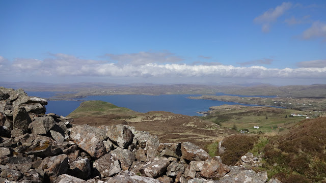
We explored the headland, finding rocks that might have been standing stones or just extrusions or randomly dropped by a glacier, others that could have been hand-carved ... or not ... and that, strangely, the GPS readings were wrong on both Joy's Garmin gadget - which claimed the spot she was taking us to was in the sea - and (when I got home) on my photo-tags.  Very weird.


We were trying to locate a rock with possible bait-holes.  We did, eventually, find something that might have been it, close to the ferry slipway - but, once again, it was probably natural rather than man-made.
<hr>

Illustrated map of our route:

Caisteal Grugaig Visit 27 June 2017

Caisteal Grugaig also known as Dun Totaig - visited on 27/6/17

Seven of us ventured out on a day which defied the weather forecast.  Rain forecast but never arrived.  We parked between Letterfearn and Totaig and met hardly anyone --apart from a hire car driven by foreigners who thought they were on the way to Eilean Donan castle!

It really is a beautiful little broch with so many of the typical broch features well preserved.  Approaching from the south in summer, as we did, high bracken hides the broch from the coastal path running from Letterfearn to Glenn.  Peering through the bracken, the incredible triangular lintel is what draws the eye.


That's when the questions start in the mind.. how many brochs have triangular rather than rectangular lintels? (several but Clachtoll in Assynt is the one that I remember best) Were the triangular lintels purely structural ie were they planned to relieve and distribute the pressure over the entrance?  Did they have some spiritual significance?  Were they simply considered more beautiful than rectangular lintels?  Once it was discovered that they did or could serve a function, such as relieving the pressure over the entrance, did they become more desirable?  Of course in the end, it may have been down to availability of the right shaped stone.  If they served an architectural function, one might suppose brochs with triangular lintels were built later than those with rectangular lintels.  There does not seem to be sufficient accurate dating of brochs to check this out.

Stepped lintels  and doorway to "guard cell" on right- Photo by Steve T


Moving into the entrance, this broch has another interesting feature.  The entrance slopes upwards and the first few lintels over the entrance are stepped upwards too.  One of these lintels forms an unusual "ceiling" check for the door.  It would also be a good place for taller and unwary visitors  to bang their heads on the way out - rather like the, now internal, doorway in my own traditional croft cottage.


From the entrance a passageway (described by Mackie, on Canmore, as an elongated guard cell)  leads off from the broch entrance.


<div class="separator" style="clear: both; text-align: center;">
</div>
From the inside of the broch, moving clockwise from the entrance. there are entrances to two furtehr cells (marked cell 2 and 3 on the plan in the previous post )


Corbelling in cell 2


The walls of cell2 display some interesting cave art -- but I was unable to convince anyone that they were prehistoric.


In cell 3, little of the roof remains but the passage leads onto a staircase which would have led up to an upper level.
The scarcement which would have supported the upper level is well preserved all around the interior although there is some question about a possible break above cells 2 and 3.


References:

https://sites.google.com/site/brochgroup/home/architecture-engineering-of-brochs
https://canmore.org.uk/site/11812/caisteal-grugaig

Illustrated map of our route:

Saturday, 24 June 2017

Caisteal Grugaig


Caisteal Grugaig -(Dun Totaig)  the witch of the north

NG86692508 
Factual details below -- for details of our visit on 27/6/17 skip to visit

Park at Letterfearn - opposite post box or drive further on twards Totaig where there are a few places to park.  The broch is a short walk, along good paths,  from Totaig House at the end of the road.

This is third of the duns/brochs we have visited bearing the same name; Dun Grugaig Skye (witch of the west) and Dun Grugaig Glenelg (witch of the east) 

Caisteal Grugaig, sometimes referred to as Dun Totaig, stands on the hill Faire an Duine, which is Gaelic for watch place of the man.(1)  The hill has excellent views over Loch Alsh, Loch Duich and Loch Long.

Grugaig  means a wretched, gloomy or sullen woman or sometimes a witch.  Please note that the references to witch of the north, west or east are purely my own invention.  

The broch is said to have been the residence of Grugaig the witch, mother of two giants Telve and Todder after whom the Glenelg brochs Telve and Trodden are named.(2)   Another story says Caisteal Grugaig was named after an old woman who could raise storms to wreck ships and cast spells on milk. (3)  On the other hand perhaps it was the same woman!


From AOC report


A description of the "clearing out" of the broch in the 19th century can be found at
http://archaeologydataservice.ac.uk/archiveDS/archiveDownload?t=arch-352-1/dissemination/pdf/vol_031//31_086_089.pdf

This is a fascinating document as it also makes reference to a vitrified wall at Eilean Donan, cup marked stones, and road markers for General Wade's roads (together with costing for these roads which indicate  that between £5 and £10,000 per yer was spent on building these roads --sadly the equivalent amount of money is not spent these days!!)

In 2010, AOC archaeology did a laser scan of the broch and the results are available in video format here:  This video is far more informative than any description I could write.


Caisteal Grugaig broch: laser scan survey from AOC Archaeology on Vimeo.

https://vimeo.com/17634384


There is some evidence of other iron age settlement nearby:  At Òb na Leòbaig,small bay of the flounder (1)  there is a wheelhouse (NG 870 254). A dun is marked on the map south of Letterfearn.  Eilean Donan castle, across the loch,was originally built in 13th century - could it have been built on the site of an earlier structure?


References:

1) translation courtesy of Jake King of Ainman-Àite na h'Alba.
2) http://www.lochalsh.co.uk/caisteal_grugaig.shtml
3) http://www.skye.co.uk/images/resources/lochalsh-leaflet.pdf
http://her.highland.gov.uk/hbsmrgatewayhighland/DataFiles/LibraryLinkFiles/193545.pdf 


Sunday, 21 May 2017

Dun Ard an t'sabhail


Dun Ard an t’sabhail
NG318333
Visited 9/5/17
Directions:
We parked beside the road near the large barn at the hairpin bend.  Room for a couple of cars well tucked in, while still allowing for passing traffic.
Our visit was during an unusually long, dry spell – could be quite a boggy trek normally.  To avoid detours and climbing fences (never a good idea – a) there is usually barbed wire in top and b) fencing is very expensive and the more people climb it the more it gets damaged) – take the gate in front and to the right of the large barn and follow the fence line up, through a second gate.  Please ensure gates are closed behind you.  The broch is situated on a high rocky crag best approached from the left.  Follow a break in the cliffs and clamber up the steep grassy slope to the summit.

The broch:
Although the broch is in quite a ruinous state, it still retains sufficient of its structure to merit a visit.  The broch is situated in an easily defended spot on top of a rocky knoll with extensive and beautiful views all around.


First view


Amazing views


David admiring the views


   A pile of tumbled stones in the northern sector is said to be the remains of a cairn.


https://canmore.org.uk/site/11076/skye-dun-ard-an-t-sabhail
Guard Cell


 The entrance and one “guard cell” to the left of the entrance are easily identified and traces of a second cell are indicated by a hollow within the walls on the other side of the entrance.


Canmore mentions a scarcement, noted in 1921 but we were unable to find any evidence of this.
 
Meaning of Ard an t'sabhail:
Most Duns or brochs are simply named after the nearest settlement.  Some of today’s names are derived from Gaelic while others are derived from Norse – both languages being rather later than the dates when the duns were constructed. We have no way of knowing what their original names were or if any of the modern names bear any resemblance to the original names.

Forbes suggests Ard an t’sabhail means the height or promontory of the barn. 
He also comments that the name could be derived from Há-fjall – high fell in Norse.  Local Gaelic speakers have informed me that the word Sàbhail can mean salvation or protection

All interesting ideas – Several people have proposed the idea that brochs were used for storing grain (eg.Harrison and Maher) which fits in nicely with the concept of Sabhail being  from Sabhal = barn but the concept of a place of safety or protection (Sàbhail = to save) is fits in with the idea of the broch being a defensive structure and place of refuge.


References


Forbes, Alexander Robert, (1923)  Place names of Skye and Adjacent Islands (digitsed by SMO http://www.smo.uhi.ac.uk/files/PDFs/00915325_Place_Names_of_Skye.pdf

Harrison, Ramona and Maher, Ruth A. (2014) Human Ecodynamics in the North Atlantic: A Collaborative Model of Humans and Nature through Space and Time,
Lexington Books